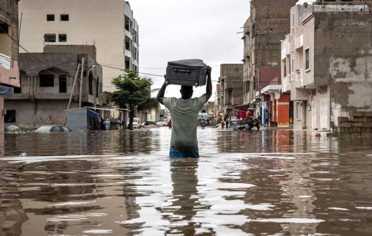
Inondations : l'étude qui révèle le vrai problème
In an interview with L'Observateur, Madické Cissé, geographer-planner and director of Flood Prevention and Management, discussed a major initiative launched by the Senegalese government to combat flooding. This initiative is based on a mapping study conducted by his department, which identified 10,000 km² of non-aedificandi zones, i.e., areas where all construction is prohibited due to their high vulnerability to flood risks.
According to the specialist, this study revealed the existence of numerous hydrographic networks, including dormant networks (waterways that are normally invisible but likely to reactivate during heavy rains). Thanks to advanced modeling techniques, these areas were mapped, which allowed President Bassirou Diomaye Faye to issue a presidential decree declaring the preservation of these natural waterways to be of public utility.
This decree now gives the government the legal means to carry out expropriations in the affected areas, in order to free up land built irregularly on former waterways or in natural basins. The objective is clear: to facilitate the natural flow of rainwater and reduce the risk of flooding in the most vulnerable areas.
The localities affected by this decree cover a large part of the national territory: Dakar, Touba, Diourbel, Kaolack, Kaffrine, Tambacounda, Kolda and Kédougou. All these areas, according to Mr. Cissé, present a similar level of vulnerability, as evidenced by the numerous floods that have recently been observed there.
Asked about the number of people affected by the expropriation plan, Cissé explained that simulations exist, based on different rainfall scenarios, to assess both the people and property likely to be affected. However, he clarified that an accurate estimate can only be provided after the census and assessment work to be carried out by specialized commissions.
The expropriation process has already begun. Following this first decree, a transfer decree will be issued, followed by a registration decree for undeveloped national land. The project is expected to last three years, in accordance with the duration defined by the presidential decree.
Regarding the overall cost of the project, the source for the daily newspaper of the Future Media Group indicated that it has not yet been fully defined, but that it will be financed gradually through commitment authorizations and payment credits included in the government's five-year flood management plan. The precise cost will be communicated after the evaluation phase.
Finally, he emphasized that this plan represents an unprecedented structural measure in the fight against flooding. According to him, freeing up waterways and prohibiting construction on natural basins is the only effective way to sustainably reduce the damage caused by heavy rains. He believes that, if this project is carried out under good conditions, it will provide significant relief to populations exposed to flooding every year.


Commentaires (2)
Rien que la carte satellitaire google maps permet de voir ces réseaux hydrographiques même dans dakar, ce sont des lignes "vertes" qui sont visibles même si c'est urbanisé.
Sur google maps, la 3D est insuffisamment précise pour faire des études d'inondation. En revanche des cartes très précises d'inondation ont été faites par à partir de laser aéroporté (Lidar). Ces crates sont accessibles en open data : chercher cartographie des zones inondables au Sénégal. Une application pour mobile très utile "Moytou Mbeund" développé par une équipe sénégalaise, utilise également ces données.
Il peut toujours pisser dans 1 tama ce sera du pareil au même !!
Participer à la Discussion